Thomas Pond factoids
The Maine Department of Environmental Protection currently says Thomas Pond is 533 acres in size. In prior years the pond size was estimated at various sizes between 446 acres to 500 acres.
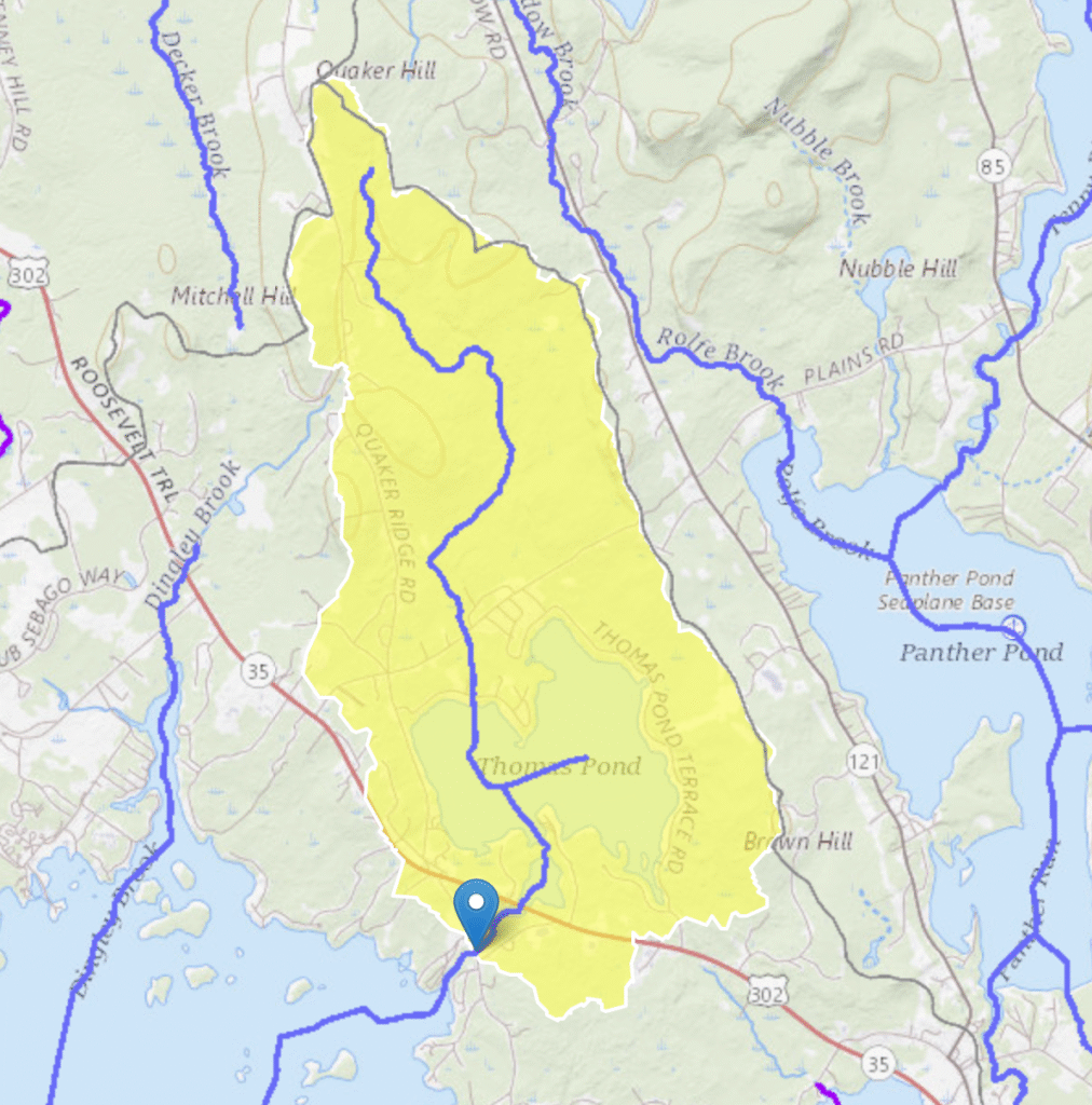
Thomas Pond’s drainage area is estimated between 4.79 and 5.5 square miles. The perimeter is estimated at 7.4 miles.
The pond has a reported average depth of 22 feet with a maximum depth of 64 feet.
Thomas Pond has a very low annual flushing rate of .53 (meaning it takes ~2 years to completely change out the water). The pond is approximately 279 feet above sea level.
Thomas Pond is referenced as MIDAS number 3392. MIDAS stands for Maine Information Display Analysis System
Why isn’t Thomas Pond a lake?
It is not deep enough. Lake vs. Pond is based on the average depth of the water body. If the water depth exceeds 25 feet on average then it is referred to as a lake; anything else is a pond. Thomas Pond has an average depth of 22 feet.
Where does Thomas Pond get its water?
Precipitation, small streams, and springs (those pesky cold spots) and ground water drainage are the major sources of water.
The drainage area for the pond is relatively small at ~5.5 square miles (see factoids above). Many lakes and ponds in Maine have a prominent source such as a river or large stream. However, Thomas Pond has only small surface creeks or streams flowing into it all around the perimeter of the pond.
Where does the water in Thomas Pond go?
Water leaves Thomas Pond by (a) evaporation, (b) drainage over the Dam into Dingley Brook and thence to Sebago Lake, (c) absorption into the groundwater and (d) ingestion and use by plants, and (e) use by humans.
We don’t have great details on the amount of water used in each of these ways, other than the amount released over the dam. However, DEP estimated that the pond will lose roughly 5 times as much water through evaporation in the summer as it will through releasing 3″ of water over the dam.
Must TPIA always release water over the dam?
TPIA is required to release a minimum amount of water over and through the dam equal to the Aquatic Base Flow (ABF) of Thomas Pond at the dam. ABF is an estimated value based on the median August flow.
At the time of the transfer of the dam to TPIA in 1990 the ABF was estimated as 2.4 cubic feet/second (cf/s). Subsequently that estimate was updated to 1.18 cf/s, and this is the amount DEP requires TPIA to release. Ignoring seepage, a flow over the dam of about 1.8″ is required.
TPIA can request permission from Maine DEP to release less water than the ABF when low water conditions occur and are expected to continue. While DEP is not required to give such approval, they often will, especially in drought conditions. In this case they will usually either allow TPIA to release a minimum of the Seasonal Aquatic Base Flow (.4 cf/s or .9″ of flow over the dam in July – Sep 15) or allow TPIA to let the flow naturally decrease as the pond level decreases.
In all cases, water flow will be restored to at least the ABF as quickly as inflows allow.
There is a great online tool, StreamStats, provided by the US Geological Service that can be used to calculate the ABF.
How much water seeps through the dam?
We have no method of measuring seepage through the dam during normal dam operations, so we measure flow without seepage.
In 2025 as part of the dam repairs we replaced all the stop logs with a new “tongue-in-groove” design with neoprene gaskets. These appear to have substantially reduced seepage.
Before the dam repairs we were able to measure seepage on three occasions. Results were .16 cf/s (at -23.5 level), .3 cf/s (at -21 level), and .5 cf/s (at -21 level). We list the pond level as a higher pond level generates more water pressure, and hence more seepage.
How does TPIA control the water level in the pond?
See our Water and Flow Management and Dam Management pages for more details.
There is a small (6 feet wide opening) dam equipped with stop logs— 4 X 4’s that are dropped into a slot in the concrete that hold back the water flowing into Dingley Brook. 2×4’s are used for fine adjustments.
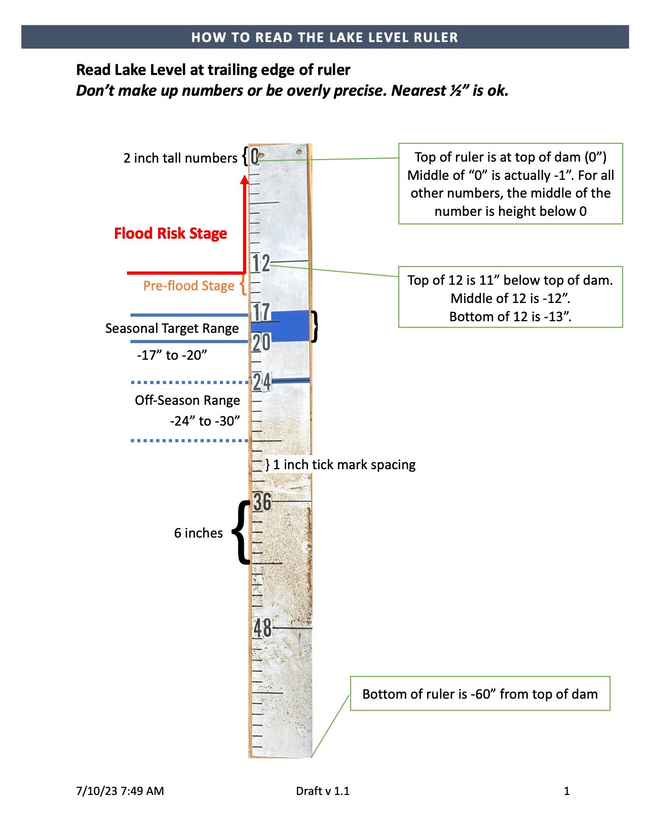
We have a Management Plan for the pond that tells the Dam Keeper the minimum and maximum flows and at what level the water should be maintained depending upon the time of year. For the summer months, when most people want to enjoy their waterfront property, the Plan says to keep the water level between 17 and 20 inches below the top of the dam.
Around October 15, when most water recreation has passed, the Dam Keeper will increase flow to allow the pond level to recede to no more than 24 inches below the top of the dam, and ideally to 27 inches below. In the Spring in anticipation of snowmelt runoff, the stop logs will be managed so as to maintain the minimum required flow, not flood the pond, and yet still “capture” enough water to gradually raise water levels to the targeted 17-20 inches.
How much impact does releasing water over the dam have?
The impact of releasing water over the dam is to always lower the pond level. The more water that goes over the dam, the faster the pond level will go down (or the slower it will rise). TPIA has created a tool to assist dam keepers in determining the impact of flows.
How did TPIA establish the water level ranges?
When TPIA was originally formed the water level ranges of 17 – 20 inches below the top of the dam in-season and at least 24 inches below the top of the dam, off-season, were established. As best we can tell this was mutually agreed upon by the founding association members and was described as “the historical levels”.
In 2023 TPIA decided to survey property owners to determine if these levels were still “mutually agreeable”, or if there was a sentiment for making changes. Overwhelmingly the response was that the 17 to 20 inch in-season range was preferred. For off-season there appeared to be a desire to establish a minimum range. See the Survey page for more information.
This feedback was incorporated into the new management plan which was overwhelmingly approved by the TPIA members at the annual meeting.
How come water levels are outside the desired target range?
Ultimately the water level in the pond is determined by mother nature. TPIA can only influence it. If there is little or no rain, pond levels will drop until they fall below our desired levels. There really isn’t anything TPIA can do about this other than keep the water flowing over the dam at the minimum allowable level.
If there is a lot of rain, pond levels will rise. TPIA takes into account weather forecasts in trying to determine when to increase or reduce flows before the pond exceeds its target range. Unfortunately, forecasts aren’t very accurate, either as to the probability of rainfall or the amount. As a result, its impossible to always predict needed changes accurately.
What we do know is that once water is gone, its gone. We also know that in-season pond levels often drop as the season goes on. Our goal is to be in range as much of the time as possible which leads us to try to keep the pond near the top of its range for most of the summer. See the Pond Level and Flow page for more info.
How is the water quality of Thomas Pond?
See the Water Quality page for more information.
The quality of the water is generally good. We are blessed in that we do not have any commercial, industrial, or major agricultural operations around the pond. Such activities disturb the soil or add contaminants that affect water quality.
Water clarity, temperature, and dissolved oxygen are tested at least monthly from Memorial Day to after Labor Day by trained and certified volunteers.
Phosphorous levels used to be checked once/year. However, Thomas Pond is considered “most at risk” and the measured phosphorous levels in 2023 were concerning. As a result, in 2024 TPIA began to test phosphorous levels more frequently and also to test the phosphorous content at 3 depths; surface, mid-depth, and near bottom. The readings for Thomas Pond are fed into a database maintained by Lakes Region of Maine on all area lakes.
Our surface phosphorous readings are generally below, but close to, the level that indicates a problem.
What can shoreline property owners do to minimize negative impact on water quality?
See the Water Quality page for more information.
#1 – Maintain or increase natural vegetation along the shore Every piece of natural vegetation helps to retain the soil and minimizes runoff, sedimentation, and erosion. If erosion is already a problem, consider adding rip-rap (after getting any necessary permits).
#2 – Minimize use of fertilizers and products containing phosphorous, and if you must fertilize, use phosphorous free fertilizers (yes, we know they aren’t as effective). If the phosphorous in the pond increases, we’re going to have algae blooms and water quality will go way down. Choose phosphorous free soaps and detergents too, every little reduction helps!
#3 – Make sure your septic system is functioning properly and is regularly pumped. A failed septic system can result in a lot of harmful bacteria getting into the lake.
#4 – If your lot is sloped toward to water use a zig zag route of your path to the water rather than a straight line downhill. There are several organizations that can give you good advice for free on how to do this including Lakes Environmental Association, Lake Stewards of Maine, and our own organization, TPIA. All have websites like this one.
Can I boat from Thomas Pond to Sebago Lake?
No. Google search results gets this one wrong.
While Thomas Pond drains into Dingley Brook which flows into Sebago Lake, the Thomas Pond Dam prevents boats of any size from moving between the two water bodies in either direction. The land on all sides of the dam is privately owned, and portage is not permitted.
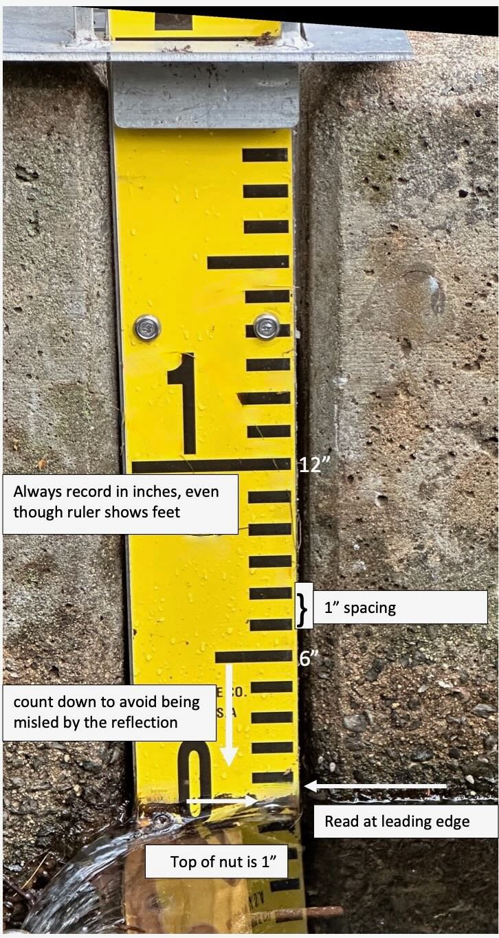
How do I “read” the pond level or water flow rulers?
Click either graphic to see the how-to-read guide for the ruler